


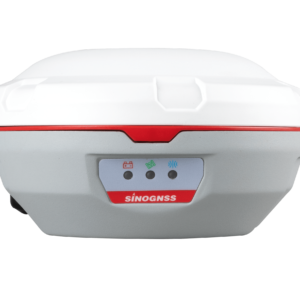
T30 IMU GNSS Receiver
T30 IMU GNSS Receiver
Description
Featuring full-constellation tracking capability, built-in IMU,
4G/WiFi/Bluetooth® connection, and easy survey workflow with
Android-based Survey Master Software, the T30 IMU GNSS receiver
is one of the most reliable choices for your demanding surveying
tasks. Collect more accurate data easier and faster no matter for
beginners or professional surveyors. The rugged Al-mg alloy housing
with IP67 Dustproof & Waterproof design makes the T30 IMU
receiver perfectly and effectively work even in harsh environments.
Features
- Support GPS L1/L2/L5, BeiDou B1/B2/B3,
GLONASS L1/L2, Galileo E1/E5a/E5b/E6/AltBOC,
QZSS L1/L2/L5, Navic L5, SBAS - BeiDou Global Signal B1C, B2a
- WIFI/UHF/4G Module
- Built-in IMU supports tilt compensation up to 60°
- Two 3400 mAh hot swap Batteries
- Low Power Consumption
- Support PPP and L-Band
Additional information
| Weight | 1.2 kg |
|---|---|
| Dimensions | 15.5 × 7.3 cm |
| Signal Tracking | 1198 channels for simultaneously tracking satellite signalsGPS, GPS – L1C/A, L2C, L2P, L5, BeiDou – B1I, B2I, B3I, B1C, B2a, B2b, GLONASS – L1, L2, Galileo – E1, E5a, E5b, E6, AltBOC, QZSS – L1C/A, L1C, L2C, L5, Navic – L5, SBAS – WAAS, EGNOS, MSAS, GAGAN, SDCM, BDSBAS, L-Band |
| Data Format | Correction data I/O – RTCM 2.x, 3.x formats, CMR(GPS only),CMR+(GPS only), Position data output – ASCII: NMEA-0183 GSV, RMC, HDT, VHD, GGA, GSA, ZDA, VTG, GST; PTNL, PJK; PTNL, AVR; PTNL, GGK ComNav Binary update to 20 Hz |
| Performance Specifications | Cold start – <50 s, Warm start – <30 s, Hot start – <15 s, Initialization time – <10 s, Signal re-acquisition – <1.5 s, Initialization reliability – >99.9% |
| Environmental | Operating temperature – -40 °C to + 65 °C, Storage temperature – -40 °C to + 85 °C, Humidity – 100% non-condensing, Waterproof and dustproof – IP67, protected from temporary immersion to depth of 1 m, Shock – Designed to Survive a 2 m drop onto concrete |
| Positioning Specifications | Static and Fast Static – 2.5 mm + 0.5 ppm Horizontal 5 mm + 0.5 ppm Vertical, Long Observations Static – 3 mm + 0.1 ppm Horizontal 3.5 mm + 0.4 ppm Vertical, Real Time Kinematic – 8 mm + 1 ppm Horizontal 15 mm + 1 ppm Vertical, DGPS – <0.4 m RMS, SBAS – 1 m 3D RMS, Standalone – 1.5m 3D RMS, PPP – 10cm Horizontal and 20cm Vertical |
| Electrical and Memory | Input voltage – 7-28 VDC, Power consumption – 1.92 W, Li-ion battery capacity – 2 × 3400 mAh, up to 16 hours typically, Memory – 8 GB |
| Communications | 1 Serial port (7 pin Lemo) Baud rates up to 921,600 bps, UHF modem: Tx/Rx with full frequency range from 410-470 MHz3 |
| Software | Survey Master Android-based data collection software, Carlson SurvCE field data collection software (optional), MicroSurvey FieldGenius field data collection software (optional) |

Reviews
There are no reviews yet.